• Skip to main content
  • Skip to header right navigation
  • Skip to after header navigation
  • Skip to site footer

Due to the lapse in federal government funding, NASA is not updating this website.

NASA classic meatball logo with the text Goddard Engineering and Technology Directorate.

Goddard Engineering and Technology Directorate

  • About ETD
    • About ETD
    • Key Personnel
    • Images
    • Multimedia
    • Featured Stories
  • Capabilities
    • ETD Capabilities
    • Capabilities Listing
    • Facilities Listing
    • core Flight System
    • Flight Dynamics Facility
    • Integrated Design Center
    • In-Space Servicing, Assembly, and Manufacturing
  • Partnerships
  • Our Work
  • Divisions
    • Wallops Engineering Office (WEO)
      • WEO Branches
    • Mechanical Systems Division (MSD)
      • MSD Branches
    • Instrument Systems & Technology Division (ISTD)
      • ISTD Branches
    • Electrical Engineering Division (EED)
      • EED Branches
    • Software Engineering Division (SED)
      • SED Branches
    • Mission Engineering & System Analysis (MESA)
      • MESA Branches
  • Careers
    • Internships

  • Our Work
  • Our Work Home
  • Contact ETD

The DAVINCI Mission

Davinci Probe Illustration. After exploring the top of Venus’s atmosphere and the composition of a mountainous region known as Alpha Regio, DAVINCI will drop its probe to the surface in 2031.

The DAVINCI (Deep Atmosphere Venus Investigation of Noble gases, Chemistry, and Imaging) mission will explore whether the inhospitable surface of Venus could once have been a twin of Earth – a habitable world with liquid water oceans.

Old Data Yields New Secrets as NASA’s DAVINCI Preps for Venus Trip

Due to launch in the early 2030s, NASA’s DAVINCI mission will investigate whether Venus — a sweltering world wrapped in an atmosphere of noxious gases — once had oceans and continents like Earth.

Consisting of a flyby spacecraft and descent probe, DAVINCI will focus on a mountainous region called Alpha Regio, a possible ancient continent. Though a handful of international spacecraft plunged through Venus’ atmosphere between 1970 and 1985, DAVINCI’s probe will be the first to capture images of this intriguing terrain ever taken from below Venus’ thick and opaque clouds.

But how does a team prepare for a mission to a planet that hasn’t seen an atmospheric probe in nearly 50 years, and that tends to crush or melt its spacecraft visitors?

Scientists leading the DAVINCI mission started by using modern data-analysis techniques to pore over decades-old data from previous Venus missions. Their goal is to arrive at our neighboring planet with as much detail as possible. This will allow scientists to most effectively use the probe’s descent time to collect new information that can help answer longstanding questions about Venus’ evolutionary path and why it diverged drastically from Earth’s.


Two nearly identical scenes are side by side. Each has a blue background with a splotchy brown and tan pattern on top of it. The image on the left is much sharper than the one on the right, with texture and shades of colors visible. A small, red ellipse marks a spot a little left of the center of the splotchy pattern.
On the left, a new and more detailed view of Venus’ Alpha Regio region developed by scientists on NASA’s DAVINCI mission to Venus, due to launch in the early 2030s. On the right is a less detailed map created using radar altimeter data collected by NASA’s Magellan spacecraft in the early 1990s. The colors on the maps depict topography, with dark blues identifying low elevations and browns identifying high elevations. To make the map on the left, the DAVINCI science team re-analyzed Magellan data and supplemented it with radar images collected on three occasions from the Arecibo Observatory in Puerto Rico by scientists from Cornell University and the Smithsonian. DAVINCI scientists then used machine-vision computer models to scrutinize the data and fill in gaps in information. The red ellipses on each image mark the area DAVINCI’s probe will descend over as it collects data on its way toward the surface. Jim Garvin/NASA’s Goddard Space Flight Center

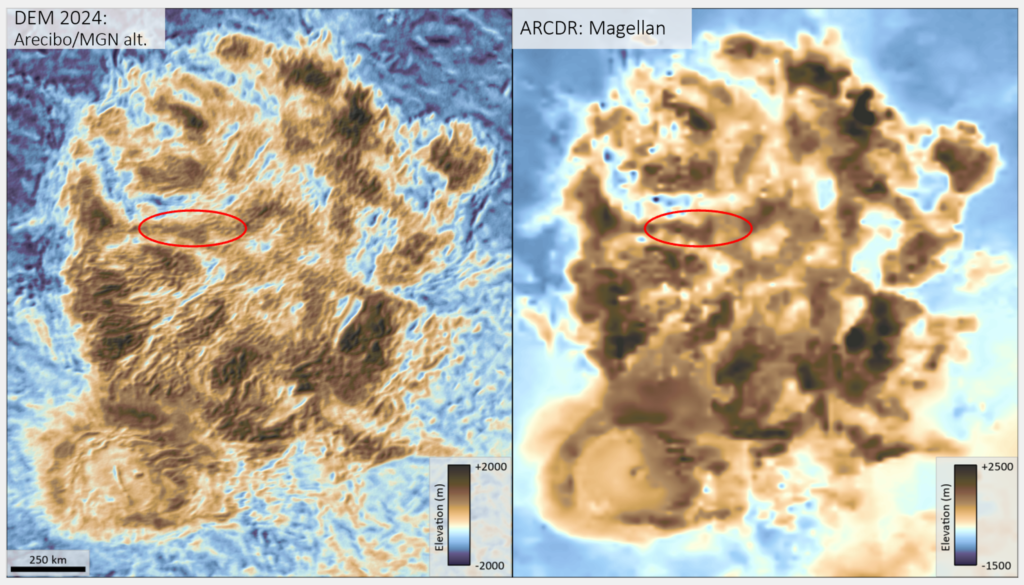
Between 1990 and 1994, NASA’s Magellan spacecraft used radar imaging and altimetry to map the topography of Alpha Regio from Venus’ orbit. Recently, NASA’s DAVINICI’s team sought more detail from these maps, so scientists applied new techniques to analyze Magellan’s radar altimeter data. They then supplemented this data with radar images taken on three occasions from the former Arecibo Observatory in Puerto Rico and used machine vision computer models to scrutinize the data and fill in gaps in information at new scales (less than 0.6 miles, or 1 kilometer).  

As a result, scientists improved the resolution of Alpha Regio maps tenfold, predicting new geologic patterns on the surface and prompting questions about how these patterns could have formed in Alpha Regio’s mountains.


Read More

ABOUT ETD

The Engineering and Technology Directorate at NASA Goddard designs, builds, and develops space flight technology for American leadership in space. The technical workforce brings this expertise to NASA’s portfolio and supports mission partnerships across the whole of government and industry.

About ETD’s Mission

NASA.gov

NASA Goddard

News & Events

NASA+

EXPLORE ETD

Key Personnel

Featured Stories

Internships

EMPLOYEES

ETD Internal

ETD Town Hall

FOLLOW

  • X
  • Facebook
  • Flickr
  • YouTube
  • Instagram

More NASA Social Accounts


NASA classic meatball logo.

Page Last Updated: Apr 23, 2025

Page Editor: ETD Web Team

Responsible NASA Official: Hector Dietsch

Sitemap

FOIA

Privacy

Accessibility

Contact ETD